Using both fixed-wing and multi-rotor drones fitted with custom-built radiation detectors, the team created 3D maps that not only reaffirmed the current understanding of the radiation distribution at an unprecedented spatial resolution, but also revealed previously undetected radiation ‘hot-spots’.
The two-week expedition, led by Professor Tom Scott of the Interface Analysis Centre and member of the National Centre for Nuclear Robotics, in April was the first of several survey missions NCNR will undertake in Ukraine over the coming 12 months. Having now reached 33 years since the catastrophic accident at the number-4 reactor, the Chernobyl exclusion zone attracted 70,000 tourists last year, and national authorities urgently required accurate radiation maps to update safety protocols that will inform both future tourism activity and the planned construction of new solar energy farms.
Cleaning up legacy nuclear waste is not only an issue at Chernobyl, with the UK itself possessing 4.9 million tons of contaminated material requiring safe long-term disposal, some of which being over 70 years old. The National Centre for Nuclear Robotics (NCNR) was created to accelerate and reduce the cost of Britain’s nuclear cleanup task by developing state of the art automation able to work in complex and hazardous environments. That expertise is now being called upon internationally.
Working alongside colleagues from Ukraine’s SSE “Eco Centre”, the body responsible for gathering survey and research data within the 2600 km2 Exclusion Zone around the failed reactor, the NCNR team flew 50 sorties over 10 days, spending 24 hours in the air to map an area of 15 km2.
Starting at the lowest risk site first, the village of Buriakivka, located 13km from the accident epicenter, researchers moved on to the partially-demolished settlement of Kopachi before tackling the Red Forest – one of the most highly-contaminated natural sites on Earth.
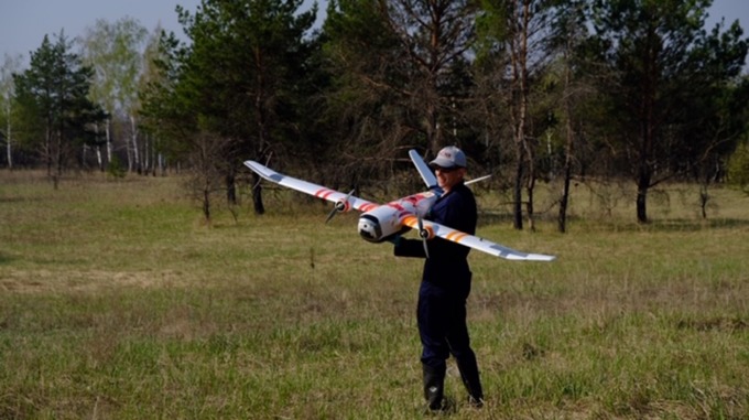
In a world first, fixed-wing drones were used to quickly map radiation over larger areas, flying at a height of 45 m - 60 m at a speed of c. 40 mph (65 km/h). Rotary drones were then used for more detailed investigation of key areas. The aircraft featured a unique sensor system developed jointly by Professor Scott’s team and University of Bristol spinout Imitec Ltd.
With the fixed-wing drone able to fly lower and slower than a manned survey aircraft ever could, and without risk to life, the NCNR team was able to create the most comprehensive radiation map yet of the Red Forest.
Their survey also pinpointed unexpected areas of major contamination in Kopachi. Registering a dose-rate of greater than 1 millisievert per hour (the maximum permissible dose not requiring an individual's classification as a Radiation Worker in the UK is 6 mSv per year), the area is believed to contain material from the original emergency cleanup activities performed over three decades ago.
Professor Scott said, “We have successfully demonstrated that the UK now has the capability to monitor radioactive sites and respond to nuclear incidents without exposing humans to risk – a guiding aim of NCNR. We can fly into a contaminated area from a safe zone, perhaps 10 km away from the incident site, and gather detailed information – streaming it live during the flight before returning safely to base”.
Professor Scott continued “The same technology has applications in other sectors too. For example, it could be used to identify rare earths, gold or copper mineral deposits, quickly, cheaply and non-invasively. This could be especially useful for developing nations keen to assess the extent and value of mineral resources ahead of, say, signing away mining rights.”