Research
Here are a few of the areas which member of our group are actively working on:
Atmospheric CO2 levels are set by an intricate set of fluxes and feedbacks – some abiotic, some biogeochemical. As we release fossil fuel CO2 and warm our planet, it is imperative that we understand how all these fluxes will respond. For instance, with ocean acidification, how will biota respond, and what will this mean for global calcification fluxes? As our climate warms and our hydrological cycle changes, how will chemical weathering fluxes respond, and what will be the effect on marine carbon cycling of enhanced nutrient run-off?
In the geochemistry group at Bristol we approach these questions from multiple angles. On a mechanistic level, we look at the chemical, physical and biological processes that control weathering fluxes on land, and at the biological responses of marine calcifiers to changing carbonate chemistry in the ocean. Scaling this to the global, and across geological time, we look to events in the geological past to teach us about how interacting biogeochemical fluxes set climate and atmospheric CO2, often combining geochemical data with Earth system modelling. For this sort of work Earth system scientists require a diverse set of geochemical tools, and so alongside application of these tools to the geological record, in the Geochemistry group we also work on the development and refinement of palaeoenvironmental proxies in both carbonate and biogenic silica.
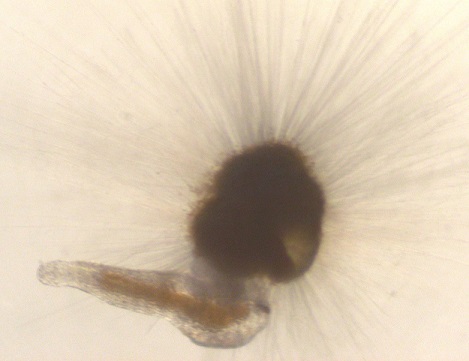
Live cultures of marine plankton provide us with improved geochemical proxies for past biogeochemical cycling
The oceans absorb and release heat and carbon – maintaining our climate system. However, much of the deep sea remains unexplored, with unanswered questions about how changes in the oceans may impact our future climate. One way to address these questions is to look back into the past, when the planet was very different from the modern day. An excellent example is the transition from the last glaciation, some 20,000 years ago when sealevel and carbon dioxide were rising, glaciers melting and the planet warmed by about 3C. We are using a huge range of field and geochemical approaches to investigate how this transition occurred.
Our research team regularly undertakes major research expeditions to explore the deep ocean, mapping and imaging the seafloor, and collecting samples needed to look at ocean climate interactions. In particular, we have focussed on deep-sea coral ecosystems. Deep sea corals are found all across the global ocean, and their skeletons form incredible archives of the past history of change. We specialise in using uranium series isotopes to document precise ages for each coral, as well as to look at processes such as the contribution of weathering to ocean chemical budgets. Together with trace metal and isotopic approaches we are able to use deep sea corals (and nearby sediment cores) to provide new data to help us understand the role of the oceans in controlling our climate.
You can watch a short video about our research.
Meteorites carry a record of the processes that occurred in the formation of our solar system. We analyse the isotopic signatures of different meteorites to gain insight into events and their timing from the collapse of the nebula to the grow of the major terrestrial planets. This includes:
- analysing fingerprints of different nuclear material input into our solar system from nearby exploding stars, which inform on the ‘birth environment’ of our solar system.
- examining how such signals are mixed within an accreting dust disk and potential power the melting of planetary bodies to make crust and core.
- investigating how the violent process of collisional growth shapes both bulk and surface characteristics of planets, in collaboration with colleagues from Physics
High precision mass-spectrometry is key to this work and we put to use the wide range of bulk and in situ techniques possible using the cutting edge instrumentation in our labs.
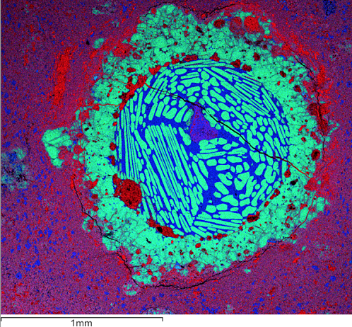
Scanning electron microscope image of a chondrule, with false colours indicating compositional differences (Green-Mg, Blue-Si and Red-Fe); the chondrule is the circular, dominantly green and blue object sitting on fine grained matrix (purple background). Chondrules are quenched silicate melt droplets (green crystals of olivine in blue glass) that are the dominant constituent of most primitive meteorites. Chondrules can be dated and provide a key chronology of events in the early solar system.
Mapping the complex spatial pattern of low-level radioactive contamination, particularly in coastal and fluvial settings, is of crucial importance for safety assessment for nuclear new build, effective decommissioning of nuclear facilities, and post-accident monitoring. Traditionally, mapping in this field relies on counting methods, which do not provide the sensitivity and specificity required to attribute source of material at ultra-trace levels and cannot provide the necessary confidence to support effective decision making. We are developing chemical separation and multi-collector mass spectrometry protocols to focus on low abundance isotopes of Pu, Cs, U and Pb for challenging environmental samples such as coastal sediments and organic materials.
Among our high-profile case studies is work dedicated to the mapping of post-accident contamination. Following the nuclear disaster in Fukushima, our research team joined forces with colleagues at the South West Nuclear Hub to assess the spatial pattern of radioactivity in the fallout zone. Autonomous unmanned aerial vehicles with miniaturised radiation detectors were used to produce high-resolution maps of contamination. Our team then developed a unique combination of nano-scale synchrotron analysis and high-precision mass-spectrometry (Pu, Cs and U) to establish the specific reactor from which highly radioactive particulates had originated.
![]()
Millions of cubic meters of radioactive soil are stored in the vicinity of the Fukushima Daiichi nuclear power plant. We are working with the Japanese Atomic Energy Agency to characterise particulate matter with high radioactivity that has been identified in the fallout. (Photo: David Richards)