To understand the geophysical processes behind the deformation signals, Biggs placed ground-based GPS monitoring equipment on two of the volcanoes within the rift – Alutu and Corbetti.
“Alutu and Corbetti had the biggest deformation signals,” said Biggs. “This was surprising as they haven’t been studied very much. There’s no monitoring and no background information regarding historical eruptions.”
There are nine GPS stations; including two reference stations that will help Biggs and her colleagues put the data collected from the volcanoes into the context of the overall movement of the rift. Each station is equipped with a GPS antenna and data recorder as well as two solar panels and a battery for power.
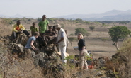
To select the location for each GPS station, Biggs had to balance the scientific ideal with the practicalities of being in the field. The stations needed to be reasonably accessible by road so they could to be serviced multiple times each year. They also needed to be at the highest points possible so that the signal being received by the antenna wasn’t masked by rocks or trees. The stations also have to be within site of a year-round guard. Local farmers , who were hired to guard the stations; had to build fences from thorny branches, to dissuade curious livestock from exploring the equipment.The GPS antenna also needed to be set into stable rock, which on these volcanoes, meant obsidian – a type of volcanic glass formed when magma cools rapidly.
Once a location was identified, Biggs and her team had to haul their heavy equipment up to the site. A large hammer drill, powered by three car batteries, was used to drill a hole into the hard rock for the antenna pin, which needed to be perfectly straight for the GPS antenna to record the satellite signals properly. The field crew had to work quickly to set the pin straight before the epoxy dried at record speed under the Ethiopian sun. The antenna was set on the pin and aligned and connected to the recorder, which collected a GPS signal from the satellites every 15 seconds[?]. The equipment is connected to the battery and solar panels and waterproofed and protected with a fence.
The data Biggs collected from these stations, and that collected from a network of seismic stations, also run by the University of Bristol, will help her interpret the deformations she is seeing from the satellite images. A better understanding of the geophysical processes underlying these volcanoes will help evaluate risk and inform monitoring efforts. It could also benefit the geothermal industry, as drilling activities are expected to begin on both Alutu and Corbetti within the next year.