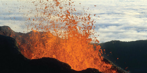
Monitoring the world’s forgotten volcanoes from space

When Iceland's Eyjafjallajökull volcano erupted in 2010 it left millions of travellers stranded and cost airlines an estimated €900 million. Now geophysicists are using satellites to provide advance warning of eruptions from other forgotten volcanoes.
Dr Juliet Biggs and her colleagues in the School of Earth Sciences are using radar satellite imagery to look at deformations in the Earth’s surface caused by underground magma flow and seismic activity – signs of volcanic unrest. The research could help establish a global monitoring system for volcanoes, which would help provide advance warning of eruption, particularly for the majority of the world’s volcanoes that are left unmonitored.
Ground-based monitoring equipment isn’t always practical
There are about 1,500 volcanoes in the world and only 100 volcano observatories. Installing ground-based monitoring equipment isn’t always possible due to the geographical remoteness of the volcano or the political climate of the region and priority is often given to volcanoes with nearby communities. However, the Iceland events illustrated the large extent of disruption that an eruption can have, and demonstrated the risk posed by leaving all these volcanoes unmonitored.
“I’ve been working recently in Ethiopia and Kenya on volcanoes that are not monitored at all, yet are showing signs of unrest,” said Biggs. “These volcanoes have no eruptive history and no hazard assessments have been done, yet they could seriously disrupt cities such as Addis Ababa and Nairobi – populations that are very vulnerable to disasters.”
Identifying signs of unrest using radar satellite images
Biggs and her colleagues have placed ground-based monitoring equipment on these volcanoes so that they can collect data to compare with the satellite imagery. This will help them understand the geophysical processes behind the deformation signals. Satellite technology is already used to remotely monitor erupting volcanoes and for early detection of eruption plumes, but it is not yet used operationally as a monitoring tool for identifying signs of unrest.
Typically, before a volcano erupts it will start to inflate, have a number of little earthquakes and start to release gases. This activity causes the Earth’s surface to move up and down. By comparing two radar satellite images taken at different times, Biggs can measure these deformations in the Earth’s surface and track how they change over time.
The satellites collect data from points on an imaginary grid covering the Earth’s surface with each of those points spaced about 90 meters apart. The satellite will collect data from each of those points every 35 days or so, providing a considerable amount of data to be managed and analysed. Currently, analysis is possible at the scale of whole countries, but in order to consider monitoring at a global scale, the analysis will need to be scaled up and automated.
In 2006, Biggs picked up some deformation signals in a volcano in Ecuador that wasn’t being monitored. She contacted the observatory who sent someone out to assess the situation: “When they got there they found a seismometer that had been placed there about 30 years ago and was still working. They downloaded the data and found that there had been a high number of long-period events, which are an indicator that magma is really moving.”
In fact, the volcano was showing more activity than Tungurahua, which has been erupting regularly since 1999, with major eruptions in 2006, 2008, 2010, 2011 and 2012: “Right now much of our work is retrospective. I saw the signal in Ecuador in 2006 and informed the Ecuadorian observatory in 2008. However, in the future we want to be able to monitor in real time and make it globally available for all volcanoes.”
Related research groups
 Study Earth Sciences
Contribute to world-leading research in an intellectually-stimulating environment.