Cost-effective flood hazard information
SSBN is translating research into cost-effective global flood hazard information, helping the insurance industry and others assess risk in regions with little information on flooding.
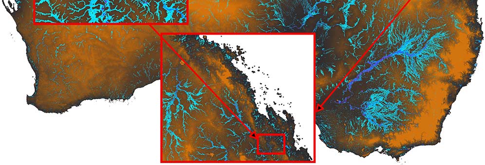
For over a decade, the University's Hydrology Group, in the School of Geographical Sciences, has been building the most efficient computer algorithms and model structures possible to simulate flood inundation, particularly in regions where few data are available. Their latest version of the LISFLOOD-FP model, can simulate flooding in megacities at 1m resolution and for the whole planet at 90m resolution.
In 2013, Professor Paul Bates, Dr Christopher Sampson, Dr Andrew Smith and Dr Jeffery Neal, all from the School of Geographical Sciences, formed SSBN. They recognised an opportunity to meet a need within the insurance and reinsurance industry while increasing the impact of their research.
Protecting populations from flood risk
In order for the insurance and reinsurance industry to prepare for potential losses due to flooding events and help those who have been affected recover from flooding, they need to understand global flood risk in detail. However, in areas such as South East Asia, where few flood data exist, this is very difficult. Yet these are some of the most vulnerable populations on the planet.
SSBN is working with clients in the insurance and reinsurance industry to provide them with cost-effective tools that help them assess flood risk in these data-poor regions. They have worked with Canopius Group, for example, a global specialty reinsurance platform of Sompo Japan Nipponkoa Holdings Inc.
'Working with SSBN has been a really positive experience for us,' said Robert Porter, Catastrophe Risk Portfolio Manager at Canopius. 'They are technical experts in their field, and through our partnership we have become much more informed about global flood risk. They have encouraged us to utilise hazard data in different ways.'
The researchers have made the LISFLOOD-FP model open access, which has also enabled the industry to build their own models to build national flood maps and price reinsurance contracts.
Governments benefit from understanding flood risk
The SSBN team has also been working with the Government of Belize as part of a project funded by the World Bank. Previously, national flood risk maps for Belize didn't exist. But SSBN has now developed the tools and national scale flood models that will help the Government of Belize make decisions about where to conduct more detailed flood risk assessments and invest in detailed design when planning new infrastructure.
Flood hazard layers accessible on Google Earth
In 2014, Bates, Neal and colleagues from the NASA Jet Propulsion Laboratory in California (US) published an opinion piece in the journal Nature, which called for industry, governments and humanitarian agencies to come together to support the development of an accurate, high resolution global digital elevation model. The article attracted the attention of the White House, and Bates, Neal and their colleagues were invited to participate in President Obama's Climate Data Initiative that was exploring ways to leverage freely accessible global climate data in new and innovative ways.
Through this initiative, the SSBN team were connected to Google and began to discuss ways they could incorporate the global flood risk map that that they were developing to the Google Earth platform. They are currently working with Google to allow their global flood risk map to be seamlessly visualised at different scales on the Google Earth platform. This is the world's first open access global flood risk map and will enable anyone with internet access to look at the potential flood risk near them.
'We think this will transform planning decisions, emergency preparedness, and disaster response,' explained Bates.
Global organisations, such as the World Bank, United Nations and Red Cross will also benefit from a global flood risk map as it could inform their operations - such as where to avoid setting up refugee camps or other humanitarian operations.
Related researchers
Related research groups
 Study Physical Geography
Join us in addressing some of the biggest challenges of the 21st century.